| From: | To: | Time: | Price: | Travel Time |
|---|---|---|---|---|
| Te Anau | Queenstown | 8:30am | $62.00 | 2 hrs & 15 mins |
| Queenstown | Te Anau | 1:30pm | $62.00 | 2 hrs & 15 mins |
| Te Anau | Divide | 10:30am | $55.00 | 1 hour & 15 mins |
| Divide | Te Anau | 3:45pm | $55.00 | 1 hour & 15 mins |
| Queenstown | Routeburn Shelter | 8:30am | $55.00 | 1 hour & 30 mins |
| Routeburn Shelter | Queenstown | 11:30am | $55.00 | 1 hour & 30 mins |
×
Bookings are now open for our Winter 2024 Great Walks transport! The Milford, Routeburn and Kepler Track Transport Packages and Sector Transport can now be booked online
QUESTIONS? CALL:
0800 483 262
EMAIL:
res@tracknet.net
Tracknet Transport offer reliable daily scheduled passenger bus and coach services to and from many of the most beautiful areas of the South Island.
Tracknet Transport
77 Manapouri-Te Anau Highway
Te Anau 9679
New Zealand
res@tracknet.net
Routeburn Track Winter Transport
Routeburn Track Loop Packages
Book your Winter Routeburn Track transport packages with Tracknet Transport
Are you an experienced hiker looking for some winter outdoor adventure? Hike the Routeburn Track during the off-season, conditions permitting. Tracknet makes booking your Routeburn Track transport with our package deals simple.

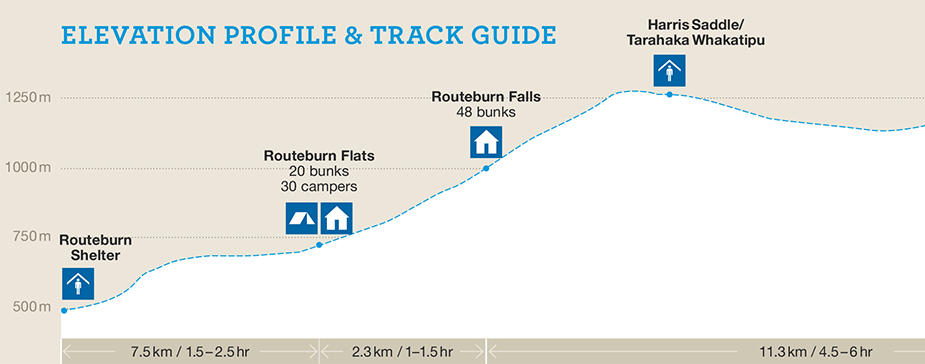
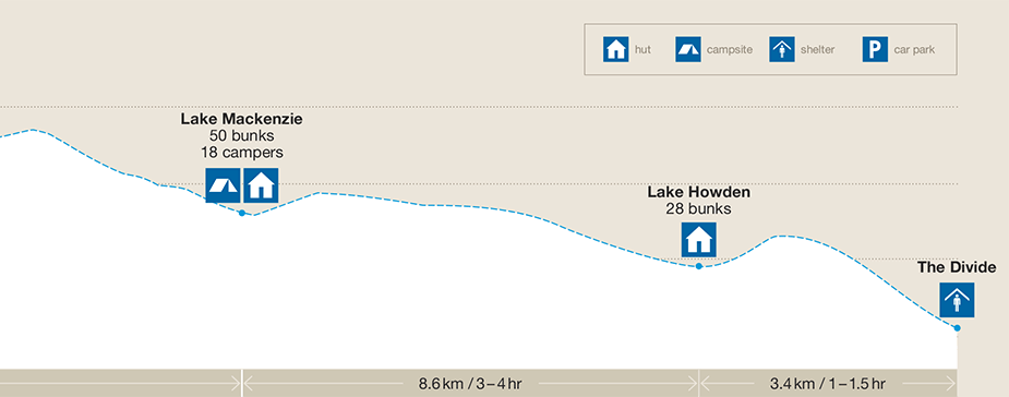
Distance:
32 kilometres
Duration:
Two or three days
Grade:
Intermediate
Accommodation:
Huts or Campsites
Entry/Exit Points:
The Divide & Routeburn Shelter
Winter Season:
Only for experienced hikers during May - October
Transport:
Book Loop Packages to the Routeburn Track from Queenstown or Te Anau with Tracknet from 2nd-20th of May 2024
The Routeburn Track can be accessed at the Divide or The Routeburn Shelter, allowing walkers flexibility to begin their journey from either end. Whether you prefer to trek from West to East or East to West, our packages are crafted to facilitate access to and from the track.
Navigating the logistics of your adventure can be overwhelming, and our knowledgeable team is here to assist you. Whether starting or finishing your journey in Queenstown or Te Anau, we've got you covered. Don't hesitate to contact us for guidance – we know the area and are here to help!
Distance:
32 kilometres
Duration:
Two or three days
Grade:
Intermediate
Accommodation:
Huts or Campsites
Entry/Exit Points:
The Divide & Routeburn Shelter
Winter Season:
Only for experienced hikers during May - October
Transport:
Book Loop Packages to the Routeburn Track from Queenstown or Te Anau with Tracknet from 2nd-20th of May 2024
How to book Routeburn Track
Tracknet make it simple for you to book your Winter Routeburn Track transport with our package deals.
MORE ABOUT TRACKBook Hut Tickets
In winter, Backcountry hut tickets are required to stay at the Huts on the Routeburn Track. Note also that hut facilities are reduced. To purchase hut tickets, go to your nearest Department of Conservation office, or find your closest Backcountry Hut
ticket retailer
Book Huts
Book Transport
Book your Routeburn Track transport packages with Tracknet. During May to October, there are once daily scheduled services to the Divide and the Routeburn Shelter. Loop packages can be booked online
Book Transport
Be Prepared!
You are responsible for your safety and ensuring that you have the correct equipment, knowledge, and experience to complete the Track. During the winter, expect that walking times may need to be increased due to more difficult walking conditions and natural hazards.
Plan Your Trip
Routeburn Track Transport Packages
The Routeburn Track starts and finishes at different locations and there are entry/exit points at the Divide and the Routeburn Shelter. Routeburn Track walkers would usually need to travel from either Te Anau or Queenstown to start the track. Tracknet offers transport 'Loop Packages' to cater for walkers travelling in either direction.
-
Depart Te Anau > Walk the Routeburn Track West to East > Return Te Anau
 +
+  + $179.00
per adult$125.00
per childDepart Te Anau:Start walking at the Divide & finish at Routeburn Shelter, bus return to Te Anau on completion of the trackBus Transport:Bus 10:30am Te Anau to Divide Shelter (1hr 15mins)Bus Transport:Bus 11:30am from Routeburn Shelter to Queenstown (1 hr 30 mins)Bus Transport:Bus 1:30pm from Queenstown to Te Anau (2 hrs 15 mins)Notes:Upon booking, transport dates can be adjusted depending on how many nights you will stay on the track -
Depart Te Anau > Walk the Routeburn Track East to West > Return Te Anau
+ + $179.00
per adult$125.00
per childDepart Te Anau:Start walking at Routeburn Shelter & finish at the Divide, bus return to Te Anau at end of track.Bus Transport:Bus 8:30am Te Anau to Queenstown (2 hrs 15 mins)Layover:Overnight in Queenstown, accommodation not includedBus Transport:Bus 8:30am from Queenstown to the Routeburn Shelter (1 hr 30 mins)Bus Transport:Bus 3:45pm from the Divide to Te Anau (1 hr 15 mins)Notes:Upon booking, transport dates can be adjusted depending on how many nights you will stay on the track -
Depart Queenstown > Walk the Routeburn Track East to West > Return Queenstown
+ + $179.00
per adult$125.00
per childDepart Queenstown:Start walking at Routeburn Shelter & finish at the Divide, bus return to Queenstown at end of the track.Bus Transport:Bus 8:30am Bus from Queenstown to the Routeburn Shelter (1 hr 30 mins)Bus Transport:Bus 3:45pm from the Divide to Te Anau (1 hr 15 mins)Layover:Overnight in Te Anau, accommodation not includedBus Transport:Bus 8:30am Te Anau to Queenstown (2 hrs 15 mins)Notes:Upon booking, transport dates can be adjusted depending on how many nights you will stay on the track -
Depart Queenstown > Walk the Routeburn Track West to East > Return Queenstown
+ + $179.00
per adult$125.00
per childDepart Queenstown:Start walking at the Divide & finish at Routeburn Shelter, bus return to QueenstownBus Transport:Bus 1:30pm Bus from Queenstown to Te Anau (2 hrs 15 mins)Layover:Overnight in Te Anau, accommodation not includedBus Transport:Bus 10:30am from Te Anau to the Divide (1 hr 15 mins)Bus Transport:Bus 11:30am from Routeburn Shelter to Queenstown (1 hr 30 mins)Notes:Upon booking, transport dates can be adjusted depending on how many nights you will stay on the track
BOOKINGS ARE ESSENTIAL
Bookings are essential to confirm your seat. Check availability, departure times and book online to receive instant email confirmation. Alternatively, if you require further details, call us on freephone: 0800 483 262.
For private transfers or charters please enquire to: res@tracknet.net.
Plan Your Trip
Routeburn Track Information
The Routeburn Track is located in the southwest of the South Island and runs between the head of Lake Wakatipu and State Highway 94, the Te Anau /Milford Road. The Routeburn Track is one of New Zealand's most popular tracks, with approximately 13,000 walkers completing the track each year. The most popular time to walk the track is during the warmer months, October to April. This time is known as the 'Great Walks Season', and due to it being very popular, hut tickets need to be purchased for specific huts. Most walkers complete the whole track in 3 days (2 nights), but longer or shorter options are available.
The Routeburn track can be walked during the cooler months of May - October by experienced and well-prepared hikers. In the off-season, huts aren't serviced, and the track may have unmarked hazards, snow and avalanche danger.
While walking on the track, you pass through tussock grasslands, herb fields, beech forests, and bog plant communities. As you pass numerous waterfalls and alpine lakes, spectacular views of U-shaped and hanging valleys dominate the landscape.
For those seeking to extend their journey, connecting with the Greenstone/Caples routes provides an opportunity for further exploration. These routes, often more accessible in winter due to their lower altitude, offer another alternative for hikers.
Tracknet Transport provides bus connections to each end of the Routeburn Track. Our service connects with The Divide Shelter on the Milford Road. The Divide is one start/finish point.
The other start/finish point of the Routeburn Track is the Routeburn Shelter, which is at the Mount Aspiring National Park end of the Routeburn Track near Glenorchy. Travelling to or away from The Routeburn Shelter, Tracknet can arrange transport for you using Info & Track's bus service.
Queenstown, Glenorchy, and Te Anau have a full range of accommodation available. Queenstown and Te Anau have shopping and hire services to cater to all walkers' needs.
Important Routeburn Track Winter Info
From May to October, the Routeburn Track will still be accessible, but there are critical safety considerations to consider before embarking into Fiordland. During the colder months, weather in Fiordland can be extreme and unpredictable. Additionally, during the Spring, avalanches can become a genuine danger. Know your limits and be prepared.
- For important information about walking the Routeburn Track in Winter, please read The Routeburn Track Winter Tramping Guide
- Backcountry Hut tickets and camp sites must be purchased. These can be bought through the Department of Conservation website.
- Check the latest weather information before going to the track.
- Leave your intentions with a trusted family member or friend. A handy form can be found at the Adventure Smart Website.
- We understand that the weather can change your plans. If you are held up on the track due to reasons outside of your control, Tracknet may carry you on the next service, provided there is availability. Additionally, Tracknet may allocate portions of your ticket paid to other operators if required, for example, if you need to turn back on the track.
Please contact us if you have any questions.
Winter Bus Timetable
Timetable May 2024
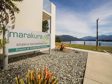
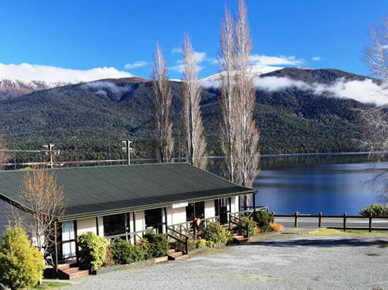
Fiordland Base Camp
The Tracknet Transport office is based at the Te Anau Lakeview Holiday Park & Motels (77 Manapouri-Te Anau Highway, Te Anau), and because of our fantastic location, we are able to offer our customers so much more than just transport! Stay with us at Fiordland's Base Camp, and take advantage of these convenient extras.
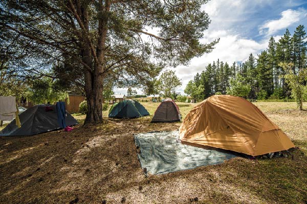
- Wide variety of accommodation options available
- Across from the Department of Conservation (DOC) office, where you can pick up your hut tickets & get up to date information about track conditions
- FREE overnight car parking
- FREE excess luggage storage
- 10 -minute walk into Te Anau town centre to supermarkets & restaurants
- Showers after your walk for $15.00 per person
- Coffee shop on site
- A short walk to Ivon Wilson Park and the Punanga Manu o Te Anau, Te Anau Bird Sanctuary
We have been organising track transport in Te Anau for over 30 years, so know what people need to get them there. Make your trip even easier and book your accommodation at the Te Anau Lakeview Holiday Park & Motels, your Fiordland Base Camp.
PARTNERS
Te Anau Lakeview Holiday Park & Motels
More details
Steamers Beach Lodge
More details